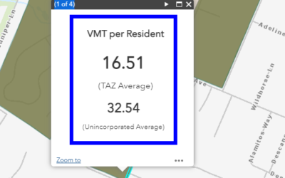
SANDAG has released the SB 743 VMT maps for both Series 14 and the historical Series 13.
SANDAG has released the SB 743 VMT maps for both Series 14 and the historical Series 13.
https://sandag.maps.arcgis.com/apps/webappviewer/index.html?id=5b4af92bc0dd4b7babbce21a7423402a
The maps provide VMT data by census tract, for use in analyzing traffic impacts during thye CEQA proceess for developments.
Be sure to review the documentation that tries to describe what is included and what is not. https://www.sandag.org/resources/maps_and_gis/interactive_maps/SB743_Documentation.pdf
And of course, the disclaimer for the data:
https://www.sandag.org/resources/maps_and_gis/interactive_maps/SB743_Data_Disclaimer_Final.pdf
They also have released an update to their Traffic Forecast Information Center (TFIC) where you can find forecasted traffic volumes by year.
https://tfic.sandag.org/
Did you see these other posts?
Stopping Sprawl Development – SB 743 Explained
A recurring theme in environmental activism in the San Diego Region has been the effort to prevent sprawl development in the rural part of the county. This has taken on a new urgency in recent years, as catastrophic wildfires have become more frequent, and the reality of climate disruption has begun to sink in.
SANDAG has rolled out the Climate Action Data Portal
SANDAG has rolled out the Climate Action Data PortalThe Climate Action Data Portal is an online resource for climate planning data for the San Diego region. Its purpose is to provide easily accessible, best available data to assist local jurisdictions in climate...
Recent Comments